IMAGES TAKEN NEAR TO
Marsh Green Road, EDENBRIDGE, TN8 5PP
Introduction
This page details the photographs taken nearby to Marsh Green Road, TN8 5PP by members of the Geograph project.
The Geograph project started in 2005 with the aim of publishing, organising and preserving representative images for every square kilometre of Great Britain, Ireland and the Isle of Man.

There are currently over 7.5m images from over14,400 individuals and you can help contribute to the project by visiting https://www.geograph.org.uk
Image Map (Loading...)


Getting Data...Please wait
Leaflet Map data © OpenStreetMap
Images are licensed for reuse under creativecommons.org/licenses/by-sa/2.0
Notes
- Clicking on the map will re-center to the selected point.
- The higher the marker number, the further away the image location is from the centre of the postcode.
Image Listing (2 Images Found)
Images are licensed for reuse under creativecommons.org/licenses/by-sa/2.0
Image
Details
Distance
1
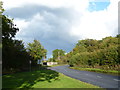
The eastern end of Marsh Green
Marsh Green was founded in 1554 under its current name. The large triangular green extends from the village at the western end away from any houses to the east. The B2028 (Marsh Green Road) follows the southern side - this is on the right here.
Marsh Green claims the last bare-knuckle boxing fight in England, in 1886.
Image: © Marathon
Taken: 11 Oct 2014
0.16 miles
2
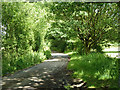
Old main road, Marsh Green
This lane around the north-western side of the village green was the only way towards Edenbridge until the straight cut-off road on the south-eastern side was built about 1900. Surprisingly, the current village green only came into being when this was done, the area being fields until then.
Image: © Robin Webster
Taken: 13 Jun 2011
0.22 miles