IMAGES TAKEN NEAR TO
Stick Hill, EDENBRIDGE, TN8 5NL
Introduction
This page details the photographs taken nearby to Stick Hill, TN8 5NL by members of the Geograph project.
The Geograph project started in 2005 with the aim of publishing, organising and preserving representative images for every square kilometre of Great Britain, Ireland and the Isle of Man.

There are currently over 7.5m images from over14,400 individuals and you can help contribute to the project by visiting https://www.geograph.org.uk
Image Map
Images are licensed for reuse under creativecommons.org/licenses/by-sa/2.0
Notes
- Clicking on the map will re-center to the selected point.
- The higher the marker number, the further away the image location is from the centre of the postcode.
Image Listing (25 Images Found)
Images are licensed for reuse under creativecommons.org/licenses/by-sa/2.0
Image
Details
Distance
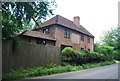
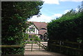
4
Entrance to Elylands, Hartfield Road
Elylands is a converted barn and worth around £1.2 million according to its current estimates online.
Image: © David Howard
Taken: 22 Apr 2012
0.05 miles
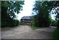
7
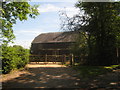
Elylands
Converted Barn on Hartfield Road near Wychwood Fruit Farm.
Image: © David Anstiss
Taken: 27 Jun 2010
0.07 miles
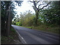
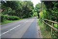
10
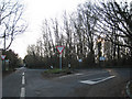
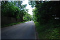
Junction of Hartfield Road
The B2026. Towards Cowden to left, Edenbridge to right.
Image: © Oast House Archive
Taken: 29 Dec 2008
0.09 miles