IMAGES TAKEN NEAR TO
Stanbridge Road, EDENBRIDGE, TN8 5JG
Introduction
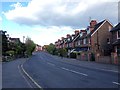
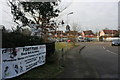
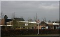
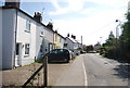
This page details the photographs taken nearby to Stanbridge Road, TN8 5JG by members of the Geograph project.
The Geograph project started in 2005 with the aim of publishing, organising and preserving representative images for every square kilometre of Great Britain, Ireland and the Isle of Man.

There are currently over 7.5m images from over14,400 individuals and you can help contribute to the project by visiting https://www.geograph.org.uk
Image Map (Loading...)


Getting Data...Please wait
Leaflet Map data © OpenStreetMap
Images are licensed for reuse under creativecommons.org/licenses/by-sa/2.0
Notes
- Clicking on the map will re-center to the selected point.
- The higher the marker number, the further away the image location is from the centre of the postcode.
Image Listing (18 Images Found)
Images are licensed for reuse under creativecommons.org/licenses/by-sa/2.0
Image
Details
Distance
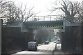
8
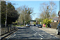
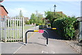
Railway bridge over B2026 Station Road, Edenbridge
Not the railway where Station Road is heading, but one further on. The line to Uckfield crosses this bridge, its Edenbridge Town station (opened 1888) is some way along the line to the right. Station Road is heading for Edenbridge station (opened 1842) on the Redhill - Tonbridge line.
Image: © Robin Webster
Taken: 17 Apr 2021
0.22 miles