IMAGES TAKEN NEAR TO
Lucilina Drive, EDENBRIDGE, TN8 5HF
Introduction
This page details the photographs taken nearby to Lucilina Drive, TN8 5HF by members of the Geograph project.
The Geograph project started in 2005 with the aim of publishing, organising and preserving representative images for every square kilometre of Great Britain, Ireland and the Isle of Man.

There are currently over 7.5m images from over14,400 individuals and you can help contribute to the project by visiting https://www.geograph.org.uk
Image Map
Images are licensed for reuse under creativecommons.org/licenses/by-sa/2.0
Notes
- Clicking on the map will re-center to the selected point.
- The higher the marker number, the further away the image location is from the centre of the postcode.
Image Listing (77 Images Found)
Images are licensed for reuse under creativecommons.org/licenses/by-sa/2.0
Image
Details
Distance
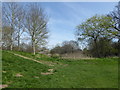
1
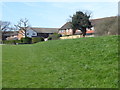
The Eden Valley Walk enters Edenbridge
This is the southern outskirts of Edenbridge on the Eden Valley Walk which turns right just ahead to reach Coomb Field. For more about the Eden Valley Walk see http://www.gps-routes.co.uk/routes/home.nsf/routeslinkswalks/eden-valley-walk-walking-route
Image: © Marathon
Taken: 26 Mar 2017
0.04 miles
3
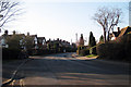
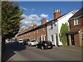
Lingfield Road, Edenbridge
Heading into town.
Image: © Robin Webster
Taken: 17 Apr 2021
0.09 miles
4
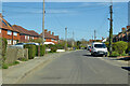
Path on flood barrier
A path leads on a large earthenbank beside the River Eden (to the right), towards Mount Saint Aignan Way.
Cobbetts Way houses are on the left.
Image: © David Anstiss
Taken: 10 Jul 2011
0.10 miles
6
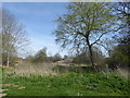
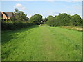
View from the Eden Valley Walk
This is on the southern outskirts of Edenbridge, looking across Mill Race which flows into the River Eden a short distance away. For more about the Eden Valley Walk see http://www.gps-routes.co.uk/routes/home.nsf/routeslinkswalks/eden-valley-walk-walking-route
Image: © Marathon
Taken: 26 Mar 2017
0.11 miles
7
View from the Eden Valley Walk
This is on the southern outskirts of Edenbridge, looking across Mill Race which flows into the River Eden a short distance away to the right. For more about the Eden Valley Walk see http://www.gps-routes.co.uk/routes/home.nsf/routeslinkswalks/eden-valley-walk-walking-route
Image: © Marathon
Taken: 26 Mar 2017
0.11 miles
8
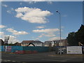
Building site on Mont St. Aignan Way
Seen from the Co-operative Superstore car park, on the other side of the road.
Image: © David Anstiss
Taken: 4 Jul 2010
0.14 miles
9
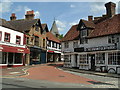
Edenbridge old shops
The parish church of St Peter and St Paul is just up the street.
Image: © Nigel Freeman
Taken: 23 Aug 2005
0.14 miles
10
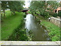
River Eden and new road bridge, Edenbridge
Image: © Ruth Sharville
Taken: 29 Aug 2010
0.15 miles