IMAGES TAKEN NEAR TO
Edenbridge Road, HARTFIELD, TN7 4JJ
Introduction
This page details the photographs taken nearby to Edenbridge Road, TN7 4JJ by members of the Geograph project.
The Geograph project started in 2005 with the aim of publishing, organising and preserving representative images for every square kilometre of Great Britain, Ireland and the Isle of Man.

There are currently over 7.5m images from over14,400 individuals and you can help contribute to the project by visiting https://www.geograph.org.uk
Image Map (Loading...)


Getting Data...Please wait
Leaflet Map data © OpenStreetMap
Images are licensed for reuse under creativecommons.org/licenses/by-sa/2.0
Notes
- Clicking on the map will re-center to the selected point.
- The higher the marker number, the further away the image location is from the centre of the postcode.
Image Listing (7 Images Found)
Images are licensed for reuse under creativecommons.org/licenses/by-sa/2.0
Image
Details
Distance
1
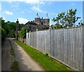
The Gatehouse, Bolebrook Castle
Located to the south west of Bolebrook Castle and dating from the 16th century. Now converted into a separate residence.
Image: © Simon Carey
Taken: 31 May 2021
0.01 miles
2
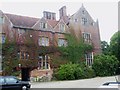
Bolebrook Castle
Reputedly the earliest brick building in Sussex (around 1480) and legend has it that Henry VIII came here to hunt the deer, wild boar and woo Ann Boleyn who lived 5 miles away at Hever.
Image: © Nigel Freeman
Taken: 24 Sep 2005
0.02 miles
3
Bolebrook Castle
Built in 1480 as a hunting lodge and reputedly used by Henry VIII when hunting deer in Ashdown Forest to the south and Anne Boleyn based at nearby Hever, 5 miles to the north.
Image: © Simon Carey
Taken: 31 May 2021
0.03 miles
5
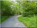
Square Barn Shaw
A belt of woodland located to the immediate east of a pair of lakes in the grounds of Bolebrook Castle.
Image: © Simon Carey
Taken: 31 May 2021
0.16 miles
6
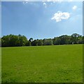
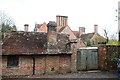
Brick Clamps
The name of the field according to Hartfield's 1842 tithe map with Bolebrook Wood beyond.
Image: © Simon Carey
Taken: 31 May 2021
0.19 miles
7
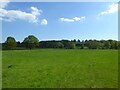
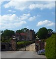
Little Mead
The name of the field according to Hartfield's 1842 tithe map bounded by the drive to Bolebrook Castle to the north. Lower Warehams Wood is in the distance to the left.
Image: © Simon Carey
Taken: 31 May 2021
0.21 miles