IMAGES TAKEN NEAR TO
Castlefields, HARTFIELD, TN7 4JA
Introduction
This page details the photographs taken nearby to Castlefields, TN7 4JA by members of the Geograph project.
The Geograph project started in 2005 with the aim of publishing, organising and preserving representative images for every square kilometre of Great Britain, Ireland and the Isle of Man.

There are currently over 7.5m images from over14,400 individuals and you can help contribute to the project by visiting https://www.geograph.org.uk
Image Map (Loading...)


Getting Data...Please wait
Leaflet Map data © OpenStreetMap
Images are licensed for reuse under creativecommons.org/licenses/by-sa/2.0
Notes
- Clicking on the map will re-center to the selected point.
- The higher the marker number, the further away the image location is from the centre of the postcode.
Image Listing (283 Images Found)
Images are licensed for reuse under creativecommons.org/licenses/by-sa/2.0
Image
Details
Distance
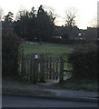
2
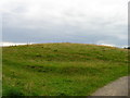
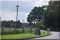
Motte and Bailey earthwork, Castlefields, Hartfield
Looking north
Image: © Simon Carey
Taken: 27 Aug 2005
0.04 miles
3
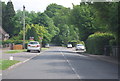
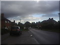
Castlefields, Hartfield
The B2110 heads east out of the village
Image: © Simon Carey
Taken: 27 Aug 2005
0.04 miles
6
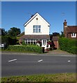
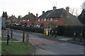
Alexander Cottage, Castlefields, Hartfield
The dwelling was built after World War One and looks out over the village green.
Image: © Simon Carey
Taken: 24 Aug 2021
0.06 miles
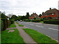
10
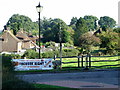
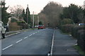
Looking towards Hartfield village green
Image: © nick macneill
Taken: 30 Sep 2011
0.06 miles