IMAGES TAKEN NEAR TO
Colemans Hatch, HARTFIELD, TN7 4HG
Introduction
This page details the photographs taken nearby to TN7 4HG by members of the Geograph project.
The Geograph project started in 2005 with the aim of publishing, organising and preserving representative images for every square kilometre of Great Britain, Ireland and the Isle of Man.

There are currently over 7.5m images from over14,400 individuals and you can help contribute to the project by visiting https://www.geograph.org.uk
Image Map (Loading...)


Getting Data...Please wait
Leaflet Map data © OpenStreetMap
Images are licensed for reuse under creativecommons.org/licenses/by-sa/2.0
Notes
- Clicking on the map will re-center to the selected point.
- The higher the marker number, the further away the image location is from the centre of the postcode.
Image Listing (37 Images Found)
Images are licensed for reuse under creativecommons.org/licenses/by-sa/2.0
Image
Details
Distance
1
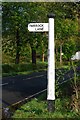
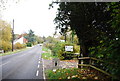
Old Direction Sign - Signpost by the B2110, Shepherds Hill
Black iron cap finial - 1 arm; East Sussex wood by the B2110, in parish of Hartfield (Wealden District), junction with Parrock Lane, on verge.
Surveyed
Milestone Society National ID: SX_TQ4434
Image: © Milestone Society
Taken: Unknown
0.05 miles
4
Site of Quabrook Gate
One of the old medieval entrances to Ashdown Forest.
Image: © Simon Carey
Taken: 26 Feb 2022
0.08 miles
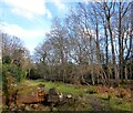
6
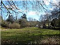
Common Field
The name of the field according to Hartfield's 1842 tithe map bounded by Parrock Lane to the north and Shepherds Hill, the B2110, to the west.
Image: © Simon Carey
Taken: 26 Feb 2022
0.09 miles
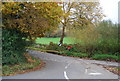
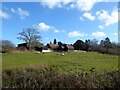
8
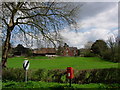
Little Parrock Farm
The farm is situated at the junction of Parrock Lane and the B2110 near to Forest Row.
Image: © Jean Barrow
Taken: 29 Apr 2006
0.10 miles
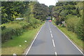
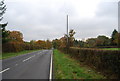
9
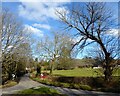
Parrock Lane
Viewed from the junction with the B2110. The lane provides access to the small hamlets of Little Parrock and Upper Parrock before rejoining the B2110 at Upper Hartfield.
Image: © Simon Carey
Taken: 26 Feb 2022
0.10 miles
10
Lodge Field
The name of the field according to Hartfield's 1842 tithe map bounded by Parrock Lane to the west and Little Parrock farm to the east.
Image: © Simon Carey
Taken: 26 Feb 2022
0.10 miles