IMAGES TAKEN NEAR TO
Kidds Hill, HARTFIELD, TN7 4EU
Introduction
This page details the photographs taken nearby to Kidds Hill, TN7 4EU by members of the Geograph project.
The Geograph project started in 2005 with the aim of publishing, organising and preserving representative images for every square kilometre of Great Britain, Ireland and the Isle of Man.

There are currently over 7.5m images from over14,400 individuals and you can help contribute to the project by visiting https://www.geograph.org.uk
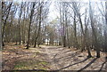
Image Map
Images are licensed for reuse under creativecommons.org/licenses/by-sa/2.0
Notes
- Clicking on the map will re-center to the selected point.
- The higher the marker number, the further away the image location is from the centre of the postcode.
Image Listing (40 Images Found)
Images are licensed for reuse under creativecommons.org/licenses/by-sa/2.0
Image
Details
Distance
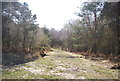
1
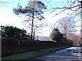
Kidd's Hill by Cobber's Farm
The Scots Pine, post and section of hedge down to the holly bush are the only items in this gridsquare on show in this image. I would estimate that the intersection of all 4 gridsquares is at a point on the grass verge to the left of the '40'on the road.
Image: © Jonathan Billinger
Taken: 6 Feb 2007
0.14 miles
6
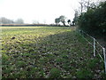
Paddock adjacent to Kidd's Hill
The view uphill to this corner of the field is in the north-east corner of the gridsquare.
Image: © Jonathan Billinger
Taken: 20 Feb 2008
0.17 miles
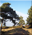
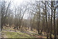
10
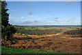
View from near top of Kidd's Hill
Looking towards the high ground north of the Medway valley and Forest Row.
Image: © Robin Webster
Taken: 19 Jan 2007
0.18 miles