IMAGES TAKEN NEAR TO
Newbridge, HARTFIELD, TN7 4ES
Introduction
This page details the photographs taken nearby to Newbridge, TN7 4ES by members of the Geograph project.
The Geograph project started in 2005 with the aim of publishing, organising and preserving representative images for every square kilometre of Great Britain, Ireland and the Isle of Man.

There are currently over 7.5m images from over14,400 individuals and you can help contribute to the project by visiting https://www.geograph.org.uk
Image Map
Images are licensed for reuse under creativecommons.org/licenses/by-sa/2.0
Notes
- Clicking on the map will re-center to the selected point.
- The higher the marker number, the further away the image location is from the centre of the postcode.
Image Listing (71 Images Found)
Images are licensed for reuse under creativecommons.org/licenses/by-sa/2.0
Image
Details
Distance
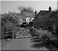
1
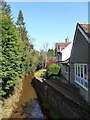
Newbridge Mill Cottage
Overlooking Mill Brook.
Image: © Simon Carey
Taken: 26 Mar 2022
0.00 miles
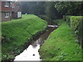
2
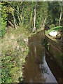
Stream at Newbridge, Ashdown Forest
Stream at Newbridge in Ashdown Forest.
Image: © Malc McDonald
Taken: 9 Oct 2010
0.01 miles
3
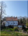
Newbridge Mill
There has been a mill here since at least the 16th century though the current building dates from 1830. The waterwheel still survives.
Image: © Simon Carey
Taken: 26 Mar 2022
0.02 miles
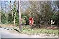
4
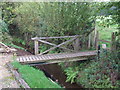
Bridge and stile, Newbridge, Ashdown Forest
Bridge and stile on a public footpath at Newbridge in Ashdown Forest.
Image: © Malc McDonald
Taken: 9 Oct 2010
0.02 miles
5
Newbridge Mill House
Dating from around 1740 with Newbridge Mill behind it. There has been a mill here since at least the 16th century though the current one dates from 1830.
Image: © Simon Carey
Taken: 26 Mar 2022
0.02 miles
6
Stream at Newbridge, Ashdown Forest
Stream passing Mill Cottage at Newbridge in Ashdown Forest.
Image: © Malc McDonald
Taken: 9 Oct 2010
0.04 miles
8
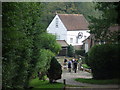
Walkers at Mill Cottage, Newbridge
Walkers on the footpath passing Mill Cottage at Newbridge.
Image: © Malc McDonald
Taken: 9 Oct 2010
0.04 miles
9
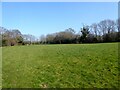
Lower Mill Field
The name of the field according to Hartfield's 1842 tithe map that is bounded by Mill Brook to the north and Newbridge Mill to the north west.
Image: © Simon Carey
Taken: 26 Mar 2022
0.06 miles
10
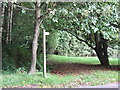
Footpath at Newbridge
Footpath at Newbridge, Ashdown Forest.
Image: © Malc McDonald
Taken: 9 Oct 2010
0.06 miles