IMAGES TAKEN NEAR TO
Cat Street, HARTFIELD, TN7 4EA
Introduction
This page details the photographs taken nearby to Cat Street, TN7 4EA by members of the Geograph project.
The Geograph project started in 2005 with the aim of publishing, organising and preserving representative images for every square kilometre of Great Britain, Ireland and the Isle of Man.

There are currently over 7.5m images from over14,400 individuals and you can help contribute to the project by visiting https://www.geograph.org.uk
Image Map (Loading...)


Getting Data...Please wait
Leaflet Map data © OpenStreetMap
Images are licensed for reuse under creativecommons.org/licenses/by-sa/2.0
Notes
- Clicking on the map will re-center to the selected point.
- The higher the marker number, the further away the image location is from the centre of the postcode.
Image Listing (30 Images Found)
Images are licensed for reuse under creativecommons.org/licenses/by-sa/2.0
Image
Details
Distance
1
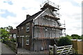
Marlpit Cottages, Cat Street, Upper Hartfield
All cottages in view were built between the wars.
Image: © Simon Carey
Taken: 26 Mar 2022
0.01 miles
8
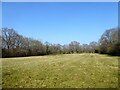
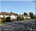
Paternoster Field
The name of the field according to Hartfield's 1842 tithe map bounded by Paternoster Wood to the west.
Image: © Simon Carey
Taken: 26 Mar 2022
0.10 miles
9
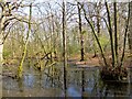
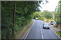
Paradise Wood
Located to the south of Cat Street, the B2110, and filled with hollows and former pits which fill in the winter.
Image: © Simon Carey
Taken: 26 Mar 2022
0.11 miles