IMAGES TAKEN NEAR TO
Balls Green, HARTFIELD, TN7 4BX
Introduction
This page details the photographs taken nearby to Balls Green, TN7 4BX by members of the Geograph project.
The Geograph project started in 2005 with the aim of publishing, organising and preserving representative images for every square kilometre of Great Britain, Ireland and the Isle of Man.

There are currently over 7.5m images from over14,400 individuals and you can help contribute to the project by visiting https://www.geograph.org.uk
Image Map
Images are licensed for reuse under creativecommons.org/licenses/by-sa/2.0
Notes
- Clicking on the map will re-center to the selected point.
- The higher the marker number, the further away the image location is from the centre of the postcode.
Image Listing (66 Images Found)
Images are licensed for reuse under creativecommons.org/licenses/by-sa/2.0
Image
Details
Distance
1
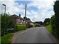
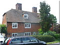
1-8, Balls Green, Balls Green, Withyham
Four pairs of semi-detached cottages built after the First World War.
Image: © Simon Carey
Taken: 29 Aug 2021
0.02 miles
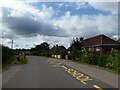
2
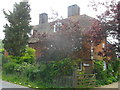
The Minions, Station Road, Balls Green, Withyham
Not marked on Withyham's 1842 tithe map but does appear on the 1874 OS map. Originally a pair of cottages but now a single residence that is marked on maps as Jefren Cottage though the name plate on the gate now indicates a change.
Image: © Simon Carey
Taken: 29 Aug 2021
0.05 miles
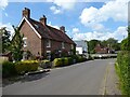
3
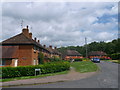
Ball's Green
Ball's Green road within the small village of Ball's Green.
This road is one of three closes of houses within the village.
All the roads are named Ball's Green, apart from Station Road leading through the village.
Jackass Shaw is a small woodland (in the background) on the edge of the village.
Image: © David Anstiss
Taken: 15 Jun 2013
0.06 miles
4
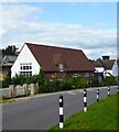
St Michael's Primary School, Station Road, Balls Green, Withyham
The original building was opened in 1877 and is still in use today albeit with a modern extension tacked onto the rear.
Image: © Simon Carey
Taken: 29 Aug 2021
0.06 miles
5
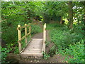
Footbridge in Jackass Shaw
A path leads from the small village of Balls Green, through a small woodland (on the edge of the village) then upwards to the B2110 Withyham Road.
The footpath passes over a bridge over a small woodland stream that flows leftwards down to the River Medway.
Image: © David Anstiss
Taken: 15 Jun 2013
0.07 miles
6
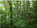
Jackass Shaw
Small wood located on the eastern side of Balls Green.
Image: © Simon Carey
Taken: 29 Aug 2021
0.08 miles
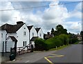
7
Blackthorn Cottage, Balls Green
A pair of a Grade II listed cottages on Station road within the village of Balls Green.
The otherhalf of the building is called Gilpin Cottage.
See http://www.britishlistedbuildings.co.uk/en-296905-gilpin-cottage-and-the-cottage-adjoining for more details about the linked cottages.
Image: © David Anstiss
Taken: 15 Jun 2013
0.08 miles
8
Gilpin Cottage, Balls Green
A pair of a Grade II listed cottages on Station road within the village of Balls Green.
The otherhalf of the building is called Blackthorn Cottage.
See http://www.britishlistedbuildings.co.uk/en-296905-gilpin-cottage-and-the-cottage-adjoining for more details about the linked cottage.
Image: © David Anstiss
Taken: 15 Jun 2013
0.08 miles
9
1-4, Station Road, Balls Green, Withyham
A pair of semi-detached cottages at the southern end of the hamlet built after the First World War.
Image: © Simon Carey
Taken: 29 Aug 2021
0.09 miles
10
Cottages, Station Road, Balls Green
Small terrace of cottages built in the late 19th century.
Image: © Simon Carey
Taken: 4 Aug 2021
0.10 miles