IMAGES TAKEN NEAR TO
Gallipot Hill, HARTFIELD, TN7 4AY
Introduction
This page details the photographs taken nearby to Gallipot Hill, TN7 4AY by members of the Geograph project.
The Geograph project started in 2005 with the aim of publishing, organising and preserving representative images for every square kilometre of Great Britain, Ireland and the Isle of Man.

There are currently over 7.5m images from over14,400 individuals and you can help contribute to the project by visiting https://www.geograph.org.uk
Image Map
Images are licensed for reuse under creativecommons.org/licenses/by-sa/2.0
Notes
- Clicking on the map will re-center to the selected point.
- The higher the marker number, the further away the image location is from the centre of the postcode.
Image Listing (37 Images Found)
Images are licensed for reuse under creativecommons.org/licenses/by-sa/2.0
Image
Details
Distance
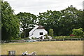
2
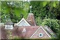
Oast House at Landhurst, Newtons Hill, Hartfield
Image: © Oast House Archive
Taken: 17 May 2013
0.04 miles
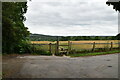
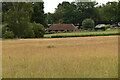
6

Halls Field
The name of the field according to Hartfield's 1842 tithe map bounded to the north by the public footpath to Hartfield.
Image: © Simon Carey
Taken: 10 Aug 2021
0.10 miles
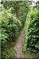
7

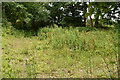
Barn Platt
The name of the field according to Hartfield's 1842 tithe map. This narrow strip once had a barn located at its northern end but that has now gone and the former field is now overgrown.
Image: © Simon Carey
Taken: 10 Aug 2021
0.11 miles