IMAGES TAKEN NEAR TO
Willinghurst Lane, CROWBOROUGH, TN6 3RY
Introduction
This page details the photographs taken nearby to Willinghurst Lane, TN6 3RY by members of the Geograph project.
The Geograph project started in 2005 with the aim of publishing, organising and preserving representative images for every square kilometre of Great Britain, Ireland and the Isle of Man.

There are currently over 7.5m images from over14,400 individuals and you can help contribute to the project by visiting https://www.geograph.org.uk
Image Map
Images are licensed for reuse under creativecommons.org/licenses/by-sa/2.0
Notes
- Clicking on the map will re-center to the selected point.
- The higher the marker number, the further away the image location is from the centre of the postcode.
Image Listing (18 Images Found)
Images are licensed for reuse under creativecommons.org/licenses/by-sa/2.0
Image
Details
Distance
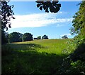
1
Lower West Field
The name of the field according to Rotherfield's 1842 tithe map located on the western side of Dewlands Hill.
Image: © Simon Carey
Taken: 21 Aug 2023
0.06 miles
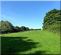
2
House Meadow
The name of the field according to Rotherfield's 1842 tithe map that is bounded to the north and east by Willinghurst Lane and to the south by the River Uck. The outbuildings of Willinghurst can be seen at the top of the slope.
Image: © Simon Carey
Taken: 21 Aug 2023
0.06 miles
3
Stone Mill, Dewlands Hill
Former 18th century mill that has now been converted into a residence.
Image: © Simon Carey
Taken: 21 Aug 2023
0.08 miles
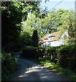
4

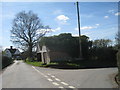
Cottages by the junction
The lane ahead is Dewlands Hill, the lane left goes towards Rotherfield.
Image: © Robin Webster
Taken: 8 Apr 2007
0.08 miles
5
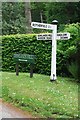
Old Direction Sign - Signpost, Dewlands Hill
Black iron cap finial - 3 arms; East Sussex wood by the UC road, in parish of Rotherfield (Wealden District), Dewlands Hill, on verge opposite junction of unnamed road with Dewlands Hill.
Surveyed
Milestone Society National ID: SX_TQ5426B.
Image: © Milestone Society
Taken: Unknown
0.09 miles
6
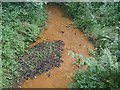
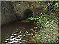
Stream flowing red
Some of the streams in the Weald can be very red in colour. I like to think that it is because of a rich seam of iron ore, but it is probably due to clay sediment.
Image: © Nigel Freeman
Taken: 21 Aug 2005
0.09 miles
7
Farm Buildings at Willinghurst
Steep Road to the right.
Image: © Oast House Archive
Taken: 10 Apr 2010
0.12 miles
8
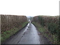
Down the lane to Willinghurst
This view southwards from Castle Hill is of the typical thickly hedged lane just below Limney Farm.
Image: © Jonathan Billinger
Taken: 24 Jan 2007
0.12 miles
9
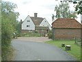
Willinghurst
There are some beautiful houses in the Weald.
Image: © Nigel Freeman
Taken: 21 Aug 2005
0.12 miles
10
Culvert under Steep Road near Pinehurst Cottage
Image: © Dave Spicer
Taken: 1 Aug 2010
0.22 miles