IMAGES TAKEN NEAR TO
Steep Road, CROWBOROUGH, TN6 3RX
Introduction
This page details the photographs taken nearby to Steep Road, TN6 3RX by members of the Geograph project.
The Geograph project started in 2005 with the aim of publishing, organising and preserving representative images for every square kilometre of Great Britain, Ireland and the Isle of Man.

There are currently over 7.5m images from over14,400 individuals and you can help contribute to the project by visiting https://www.geograph.org.uk
Image Map
Images are licensed for reuse under creativecommons.org/licenses/by-sa/2.0
Notes
- Clicking on the map will re-center to the selected point.
- The higher the marker number, the further away the image location is from the centre of the postcode.
Image Listing (7 Images Found)
Images are licensed for reuse under creativecommons.org/licenses/by-sa/2.0
Image
Details
Distance
1
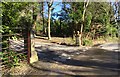
Entrance to Highwell House
Stone Pillars beside the entrance to Highwell House at Steep Park.
Image: © Chris Thomas-Atkin
Taken: 16 Feb 2018
0.02 miles
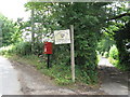
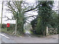
3
Gated rear entrance to Shambles Cottage on Steep Road
Image: © Dave Spicer
Taken: 1 Aug 2010
0.06 miles
4
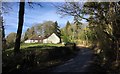
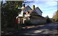
House near Steep Park
Approaching Steep Park on Steep Road.
Image: © Chris Thomas-Atkin
Taken: 16 Feb 2018
0.07 miles
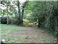
7

For Sale off Steep Road
Steep Road bends round to the left. Down a long drive on the right is "Farmhouse, outbuildings and 64 acres" which are for sale. This can only be Rumsden Farm, whose sign is above the for sale sign, and advertises Charolais breeding. Will or does the enterprise continue elsewhere? The company website seems to be vibrant.
Image: © Robin Webster
Taken: 9 Feb 2012
0.08 miles