IMAGES TAKEN NEAR TO
Dewlands Hill, CROWBOROUGH, TN6 3RU
Introduction
This page details the photographs taken nearby to Dewlands Hill, TN6 3RU by members of the Geograph project.
The Geograph project started in 2005 with the aim of publishing, organising and preserving representative images for every square kilometre of Great Britain, Ireland and the Isle of Man.

There are currently over 7.5m images from over14,400 individuals and you can help contribute to the project by visiting https://www.geograph.org.uk
Image Map
Images are licensed for reuse under creativecommons.org/licenses/by-sa/2.0
Notes
- Clicking on the map will re-center to the selected point.
- The higher the marker number, the further away the image location is from the centre of the postcode.
Image Listing (27 Images Found)
Images are licensed for reuse under creativecommons.org/licenses/by-sa/2.0
Image
Details
Distance
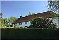
2
Great Dewlands, Dewlands Hill
Dating back to the 17th century.
Image: © Simon Carey
Taken: 21 Aug 2023
0.01 miles
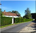
4
Near to Great Dewlands
Heading South towards Coes Farm.
Image: © Chris Thomas-Atkin
Taken: 8 May 2018
0.03 miles
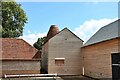
5
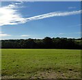
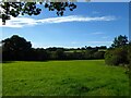
Five Acres
The name of the field according to Rotherfield's 1842 tithe map bounded by Dewlands Hill to the east.
Image: © Simon Carey
Taken: 21 Aug 2023
0.08 miles
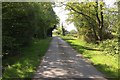
6
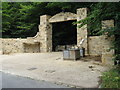
Progress on new entrance to Briar House Farm
Compared to Oast House Archives photo on the 10th April Image the gateway is well advanced.
Image: © Dave Spicer
Taken: 1 Aug 2010
0.09 miles
7
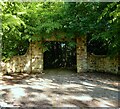
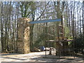
Entrance, Briars House, Dewlands Hill
Constructed in 2010, see Image
Image: © Simon Carey
Taken: 21 Aug 2023
0.11 miles
8
Entrance to Briar House Farm
The stone of this impressive gateway is now looking more mature compared to the original build some 8 years previous. See Image
Image: © Chris Thomas-Atkin
Taken: 8 May 2018
0.11 miles
9
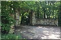
Lodge Plot
The name of the field according to Rotherfield's 1842 tithe map located on the western side of Dewlands Hill.
Image: © Simon Carey
Taken: 21 Aug 2023
0.12 miles
10
New entrance gate to Briar House
Partly constructed steel framed, stone entrance gate.
Image: © Oast House Archive
Taken: 10 Apr 2010
0.12 miles