IMAGES TAKEN NEAR TO
Wadhurst Road, CROWBOROUGH, TN6 3PE
Introduction
This page details the photographs taken nearby to Wadhurst Road, TN6 3PE by members of the Geograph project.
The Geograph project started in 2005 with the aim of publishing, organising and preserving representative images for every square kilometre of Great Britain, Ireland and the Isle of Man.

There are currently over 7.5m images from over14,400 individuals and you can help contribute to the project by visiting https://www.geograph.org.uk
Image Map
Images are licensed for reuse under creativecommons.org/licenses/by-sa/2.0
Notes
- Clicking on the map will re-center to the selected point.
- The higher the marker number, the further away the image location is from the centre of the postcode.
Image Listing (32 Images Found)
Images are licensed for reuse under creativecommons.org/licenses/by-sa/2.0
Image
Details
Distance
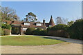
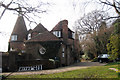
6
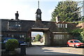
The Oast House at Bassetts
Several paths meet at Bassetts which is at the southern end of Bassetts Lane. It is a far more extensive property than appears here.
Image: © Marathon
Taken: 4 Sep 2021
0.04 miles
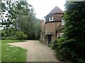
7
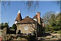
The Oast House, Wadhurst Road, Mark Cross, East Sussex
Two of the kiln roofs have been modified to gambrel style double pitch roofs. The style is common to the area. Also see Image & Image
Image: © Oast House Archive
Taken: 21 Mar 2009
0.04 miles
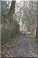
10
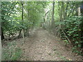
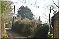
Footpath through woodland
This is just beyond Bassetts and on the way to Earl's Farm and eventually Mark Cross.
Image: © Marathon
Taken: 4 Sep 2021
0.07 miles