IMAGES TAKEN NEAR TO
High Street, CROWBOROUGH, TN6 3LJ
Introduction
This page details the photographs taken nearby to High Street, TN6 3LJ by members of the Geograph project.
The Geograph project started in 2005 with the aim of publishing, organising and preserving representative images for every square kilometre of Great Britain, Ireland and the Isle of Man.

There are currently over 7.5m images from over14,400 individuals and you can help contribute to the project by visiting https://www.geograph.org.uk
Image Map
Images are licensed for reuse under creativecommons.org/licenses/by-sa/2.0
Notes
- Clicking on the map will re-center to the selected point.
- The higher the marker number, the further away the image location is from the centre of the postcode.
Image Listing (106 Images Found)
Images are licensed for reuse under creativecommons.org/licenses/by-sa/2.0
Image
Details
Distance
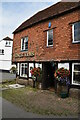
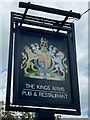
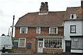
7
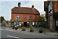
Kings Arms
Grade II listed. https://historicengland.org.uk/listing/the-list/list-entry/1028144
Image: © N Chadwick
Taken: 8 Sep 2020
0.02 miles
10
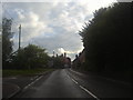
Station Road, Rotherfield
Rotherfield and Marks Cross station complete with the line from Uckfield closed in June 1965. http://www.disused-stations.org.uk/r/rotherfield_and_mark_cross/index.shtml
Image: © David Howard
Taken: 29 Jul 2012
0.03 miles