IMAGES TAKEN NEAR TO
Church Road, CROWBOROUGH, TN6 3LB
Introduction
This page details the photographs taken nearby to Church Road, TN6 3LB by members of the Geograph project.
The Geograph project started in 2005 with the aim of publishing, organising and preserving representative images for every square kilometre of Great Britain, Ireland and the Isle of Man.

There are currently over 7.5m images from over14,400 individuals and you can help contribute to the project by visiting https://www.geograph.org.uk
Image Map
Images are licensed for reuse under creativecommons.org/licenses/by-sa/2.0
Notes
- Clicking on the map will re-center to the selected point.
- The higher the marker number, the further away the image location is from the centre of the postcode.
Image Listing (102 Images Found)
Images are licensed for reuse under creativecommons.org/licenses/by-sa/2.0
Image
Details
Distance
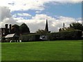
3
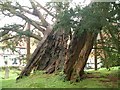
Yew Tree in Rotherfield Churchyard
The hulk of an ancient yew tree which although hollow and leaning is still alive. This veteran certainly pre-dates the church, and possibly even Christianity itself!
Image: © David Saunders
Taken: 16 Oct 2004
0.08 miles
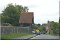
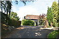
5
Chapel Cottages
Grade II listed. https://historicengland.org.uk/listing/the-list/list-entry/1193886
Image: © N Chadwick
Taken: 8 Sep 2020
0.08 miles
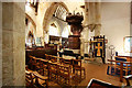
7
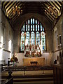
St. Denys, Rotherfield, East Sussex
A wonderful church with wall paintings, box pews and a superb Burne-Jones and Morris window.
Image: © nick macneill
Taken: 1 Jan 2010
0.12 miles