IMAGES TAKEN NEAR TO
Oakwood Mews, CROWBOROUGH, TN6 3FJ
Introduction
This page details the photographs taken nearby to Oakwood Mews, TN6 3FJ by members of the Geograph project.
The Geograph project started in 2005 with the aim of publishing, organising and preserving representative images for every square kilometre of Great Britain, Ireland and the Isle of Man.

There are currently over 7.5m images from over14,400 individuals and you can help contribute to the project by visiting https://www.geograph.org.uk
Image Map
Images are licensed for reuse under creativecommons.org/licenses/by-sa/2.0
Notes
- Clicking on the map will re-center to the selected point.
- The higher the marker number, the further away the image location is from the centre of the postcode.
Image Listing (91 Images Found)
Images are licensed for reuse under creativecommons.org/licenses/by-sa/2.0
Image
Details
Distance
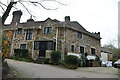
1
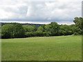
Footpath approach to Jarvis Brook and Crowborough
Image: © Dave Spicer
Taken: 1 Aug 2010
0.02 miles

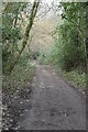
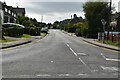
5

Restricted Byway on the SE corner of Crowborough
Image: © Dave Spicer
Taken: 1 Aug 2010
0.10 miles
7
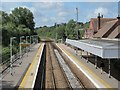
Crowborough station (2)
Looking southwest (towards Uckfield) from the footbridge.
Image: © Mike Quinn
Taken: 22 Aug 2012
0.14 miles
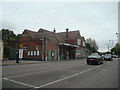
10
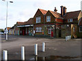
Crowborough Station
Located two miles from the town centre in Jarvis Brook. It was opened in 1868 and was originally called Rotherfield but then changed to Crowborough and Jarvis Brook which remained the name until the 1970s when it was shortened to just Crowborough.
Image: © Simon Carey
Taken: 20 Jan 2007
0.15 miles