IMAGES TAKEN NEAR TO
Western Road, CROWBOROUGH, TN6 3ET
Introduction
This page details the photographs taken nearby to Western Road, TN6 3ET by members of the Geograph project.
The Geograph project started in 2005 with the aim of publishing, organising and preserving representative images for every square kilometre of Great Britain, Ireland and the Isle of Man.

There are currently over 7.5m images from over14,400 individuals and you can help contribute to the project by visiting https://www.geograph.org.uk
Image Map
Images are licensed for reuse under creativecommons.org/licenses/by-sa/2.0
Notes
- Clicking on the map will re-center to the selected point.
- The higher the marker number, the further away the image location is from the centre of the postcode.
Image Listing (45 Images Found)
Images are licensed for reuse under creativecommons.org/licenses/by-sa/2.0
Image
Details
Distance
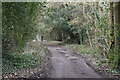
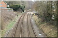
1
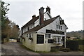
Western Road, Jarvis Brook
Jarvis Brook is another small settlement that has been swallowed by the conurbation of Crowborough.
Image: © Simon Carey
Taken: 20 Jan 2007
0.06 miles
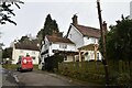
2
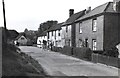
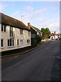
Jarvis Brook
Old photograph taken in 1954. These buildings are in Western Road and still exist today.
Image: © Leslie Whitcomb
Taken: 28 Aug 1954
0.07 miles
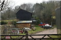
9
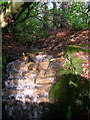
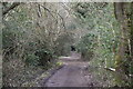
Small Waterfall, Stableford, Mount Pleasant
Carrying a small stream one of many that run off Crowborough Hill. The top of the waterfall is at eye level though the bottom is underneath a small bridge.
Image: © Simon Carey
Taken: 20 Jan 2007
0.12 miles