IMAGES TAKEN NEAR TO
Eridge Road, CROWBOROUGH, TN6 2XA
Introduction
This page details the photographs taken nearby to Eridge Road, TN6 2XA by members of the Geograph project.
The Geograph project started in 2005 with the aim of publishing, organising and preserving representative images for every square kilometre of Great Britain, Ireland and the Isle of Man.

There are currently over 7.5m images from over14,400 individuals and you can help contribute to the project by visiting https://www.geograph.org.uk
Image Map
Images are licensed for reuse under creativecommons.org/licenses/by-sa/2.0
Notes
- Clicking on the map will re-center to the selected point.
- The higher the marker number, the further away the image location is from the centre of the postcode.
Image Listing (29 Images Found)
Images are licensed for reuse under creativecommons.org/licenses/by-sa/2.0
Image
Details
Distance
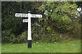
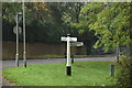
2
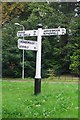
Direction Sign - Signpost by the B2157, Green Lane, Crowborough
Black iron cap finial - 3 arms; East Sussex wood by the B2157, in parish of Crowborough (Wealden District), Eridge Road junction with Green Lane (NB: All three roads at this T-junction are the B2157).
Surveyed
Milestone Society National ID: SX_TQ5331
Image: © Milestone Society
Taken: Unknown
0.05 miles
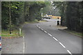
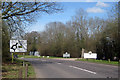
4
Fingerpost on Eridge Road, Steel Cross
Image: © David Howard
Taken: 22 Apr 2012
0.05 miles
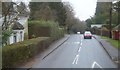
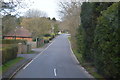
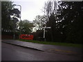
9
Eridge Road
Entrance to Boars Head Golf Centre to right.
Image: © Oast House Archive
Taken: 10 Apr 2010
0.11 miles