IMAGES TAKEN NEAR TO
Jefferies Way, CROWBOROUGH, TN6 2UL
Introduction
This page details the photographs taken nearby to Jefferies Way, TN6 2UL by members of the Geograph project.
The Geograph project started in 2005 with the aim of publishing, organising and preserving representative images for every square kilometre of Great Britain, Ireland and the Isle of Man.

There are currently over 7.5m images from over14,400 individuals and you can help contribute to the project by visiting https://www.geograph.org.uk
Image Map
Images are licensed for reuse under creativecommons.org/licenses/by-sa/2.0
Notes
- Clicking on the map will re-center to the selected point.
- The higher the marker number, the further away the image location is from the centre of the postcode.
Image Listing (18 Images Found)
Images are licensed for reuse under creativecommons.org/licenses/by-sa/2.0
Image
Details
Distance
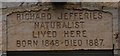
4
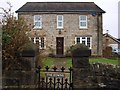
Richard "The Story of My Heart" Jefferies lived here.
Image: © tristan forward
Taken: 5 Feb 2010
0.16 miles
6
Inscribed Lintel at Richard Jefferies' House
Image: © tristan forward
Taken: 5 Feb 2010
0.17 miles
7
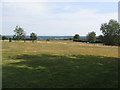
Crowborough sports and recreation area
Beyond and below the bench is a children's playground, then two level sports fields and an expansive view of Wealden landscape with large areas of woodland.
Image: © E Gammie
Taken: 19 Jul 2018
0.19 miles