IMAGES TAKEN NEAR TO
Forest Rise, CROWBOROUGH, TN6 2EP
Introduction
This page details the photographs taken nearby to Forest Rise, TN6 2EP by members of the Geograph project.
The Geograph project started in 2005 with the aim of publishing, organising and preserving representative images for every square kilometre of Great Britain, Ireland and the Isle of Man.

There are currently over 7.5m images from over14,400 individuals and you can help contribute to the project by visiting https://www.geograph.org.uk
Image Map
Images are licensed for reuse under creativecommons.org/licenses/by-sa/2.0
Notes
- Clicking on the map will re-center to the selected point.
- The higher the marker number, the further away the image location is from the centre of the postcode.
Image Listing (29 Images Found)
Images are licensed for reuse under creativecommons.org/licenses/by-sa/2.0
Image
Details
Distance
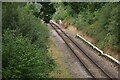
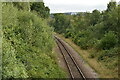
4
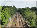
Railway lines northeast of Crowborough station
Image: © Mike Quinn
Taken: 22 Aug 2012
0.13 miles
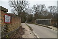
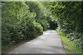
6
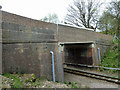
Bridge SCU1 1028, Uckfield Line
Although recently rebuilt with a new concrete span and bearing blocks, the bridge is still signed by the highway authority as weak, and subject to a 7.5 tonne weight limit. It probably suits them to keep a weight restriction on the narrow lane anyway.
Image: © Robin Webster
Taken: 14 Apr 2011
0.13 miles
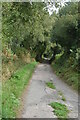
8
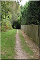
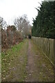
Footpath along the side of the railway line
Image: © N Chadwick
Taken: 8 Sep 2020
0.14 miles