IMAGES TAKEN NEAR TO
East Beeches Road, CROWBOROUGH, TN6 2BA
Introduction
This page details the photographs taken nearby to East Beeches Road, TN6 2BA by members of the Geograph project.
The Geograph project started in 2005 with the aim of publishing, organising and preserving representative images for every square kilometre of Great Britain, Ireland and the Isle of Man.

There are currently over 7.5m images from over14,400 individuals and you can help contribute to the project by visiting https://www.geograph.org.uk
Image Map
Images are licensed for reuse under creativecommons.org/licenses/by-sa/2.0
Notes
- Clicking on the map will re-center to the selected point.
- The higher the marker number, the further away the image location is from the centre of the postcode.
Image Listing (13 Images Found)
Images are licensed for reuse under creativecommons.org/licenses/by-sa/2.0
Image
Details
Distance
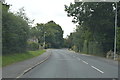
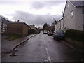
1
Junction of Green Lane and Hillrise, Crowborough
Image: © David Howard
Taken: 22 Apr 2012
0.10 miles
2
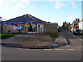
Poundfield Stores and Post Office, Green Lane, Poundfield
On the junction of Green Lane (B2157) and Poundfield Road. Poundfield is another hamlet swalled up by Crowborough.
Image: © Simon Carey
Taken: 20 Jan 2007
0.10 miles
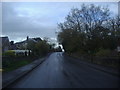
3
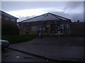
Poundfield Stores on Green Lane, Crowborough
Image: © David Howard
Taken: 22 Apr 2012
0.11 miles
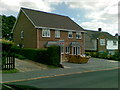
8
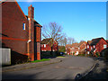
Pellings Farm Close, Poundfield
Recent addition to Crowborough's suburbia.
Image: © Simon Carey
Taken: 20 Jan 2007
0.20 miles
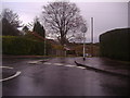
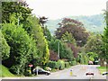
9

Police Station, Crowborough Hill, Sussex
Located at the junction of Crowborough Hill (B2100), and North Beeches Road.
Image: © Peter Trimming
Taken: 26 Apr 2011
0.20 miles