IMAGES TAKEN NEAR TO
Fielden Road, CROWBOROUGH, TN6 1TR
Introduction
This page details the photographs taken nearby to Fielden Road, TN6 1TR by members of the Geograph project.
The Geograph project started in 2005 with the aim of publishing, organising and preserving representative images for every square kilometre of Great Britain, Ireland and the Isle of Man.

There are currently over 7.5m images from over14,400 individuals and you can help contribute to the project by visiting https://www.geograph.org.uk
Image Map
Images are licensed for reuse under creativecommons.org/licenses/by-sa/2.0
Notes
- Clicking on the map will re-center to the selected point.
- The higher the marker number, the further away the image location is from the centre of the postcode.
Image Listing (11 Images Found)
Images are licensed for reuse under creativecommons.org/licenses/by-sa/2.0
Image
Details
Distance
1
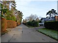
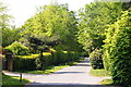
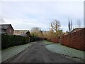
Fielden Road, Crowborough
A private residential road linking Beacon Road, the A26, to Glenmore Road. The section in view up to Warren Road had been laid out by the 1870 but building did not really commence until the second and third decades of the 20th century.
Image: © Simon Carey
Taken: 22 Dec 2021
0.07 miles
3
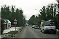
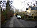
Warren Road, Crowborough
Looking back to the crossroads with Fielden Road. Warren Road was once part of an old route linking East Grinstead to Rotherfield.
Image: © Simon Carey
Taken: 22 Dec 2021
0.16 miles
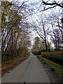
7
Warren Road, Crowborough, Sussex
A private road, but public bridleway, leading to the Ashdown Forest.
Image: © Peter Trimming
Taken: 26 Apr 2011
0.19 miles
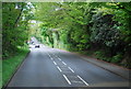
8
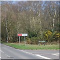
A26 - beware elderly people
There must be a home somewhere around here, but it was not obvious.
Image: © Robin Webster
Taken: 9 Feb 2012
0.19 miles
9
Heavegate Road, Crowborough
A cul de sac off Fielden Road that was originally laid out in the late 19th century as a through route to Warren Road next to the house called Heavegate. Houses were built piecemeal from that date onwards.
Image: © Simon Carey
Taken: 22 Dec 2021
0.21 miles
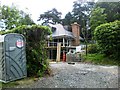
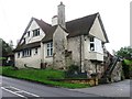
10
Heavegate Cottages, Warren Road
Marked on Withyham's 1841 tithe map and located at the site of one of the old gates into Ashdown Forest, the former pale crossing Warren Road at the point where I am standing. The area known as Crowborough Warren was enclosed in the late 17th century. Warren Road itself was a very old route linking East Grinstead to Rotherfield across the forest.
Image: © Simon Carey
Taken: 22 Dec 2021
0.22 miles