IMAGES TAKEN NEAR TO
School Lane, CROWBOROUGH, TN6 1PB
Introduction
This page details the photographs taken nearby to School Lane, TN6 1PB by members of the Geograph project.
The Geograph project started in 2005 with the aim of publishing, organising and preserving representative images for every square kilometre of Great Britain, Ireland and the Isle of Man.

There are currently over 7.5m images from over14,400 individuals and you can help contribute to the project by visiting https://www.geograph.org.uk
Image Map
Images are licensed for reuse under creativecommons.org/licenses/by-sa/2.0
Notes
- Clicking on the map will re-center to the selected point.
- The higher the marker number, the further away the image location is from the centre of the postcode.
Image Listing (8 Images Found)
Images are licensed for reuse under creativecommons.org/licenses/by-sa/2.0
Image
Details
Distance
3
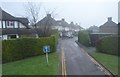
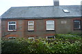
Queen's Road, Crowborough
Carlton Terrace on the right, part of a succession of houses using quite a lot of the local stone as well as brick.
Image: © Robin Webster
Taken: 9 Feb 2012
0.19 miles
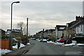
6
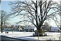
Chapel Green, Crowborough
A view of Chapel Green from Church Road
Image: © Geoff Cooper
Taken: 6 Jan 2003
0.24 miles
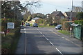
7
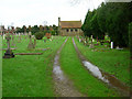
Crowborough Cemetery
Small sandstone chapel of rest in the town's cemetery of Herne Road.
Image: © Simon Carey
Taken: 20 Jan 2007
0.25 miles
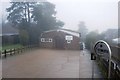
8
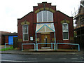
The Whitehill Centre, Whitehill Road
The road is on a slope hence the strange angle of the building. Small hall which became a council owned community centre in 1994 opened by a granddaughter of Sir Arthur Conan Doyle.
Image: © Simon Carey
Taken: 20 Jan 2007
0.25 miles