IMAGES TAKEN NEAR TO
Gorsedene Close, CROWBOROUGH, TN6 1FJ
Introduction
This page details the photographs taken nearby to Gorsedene Close, TN6 1FJ by members of the Geograph project.
The Geograph project started in 2005 with the aim of publishing, organising and preserving representative images for every square kilometre of Great Britain, Ireland and the Isle of Man.

There are currently over 7.5m images from over14,400 individuals and you can help contribute to the project by visiting https://www.geograph.org.uk
Image Map
Images are licensed for reuse under creativecommons.org/licenses/by-sa/2.0
Notes
- Clicking on the map will re-center to the selected point.
- The higher the marker number, the further away the image location is from the centre of the postcode.
Image Listing (9 Images Found)
Images are licensed for reuse under creativecommons.org/licenses/by-sa/2.0
Image
Details
Distance
2
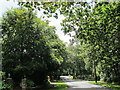
Crowborough Hill
Crowborough Hill is an English Marilyn at a height of 242m. The trig point is well hidden on water board property under the radio mast.
Image: © AlanC
Taken: 3 Jul 2004
0.19 miles
7
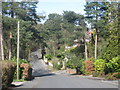
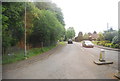
Crowborough Warren
The Warren is totally overbuilt with low density housing. This is Aviemore Road and is typical. The Scottish road names in this part derive from the time when the town was being sold as a Victorian health resort known due to its height as Scotland of the south.
Image: © Robin Webster
Taken: 27 Jan 2007
0.22 miles
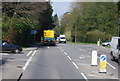
8
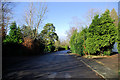
Low Density Housing on Kings Chase
In the posh part of Crowborough.
Image: © Robin Webster
Taken: 27 Jan 2007
0.22 miles
9
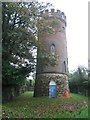
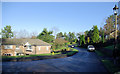
Beacon Water Tower, Crowborough
Beacon Water Tower and covered reservoir plus a trig point are located close together. This used to be classed as the Marilyn high point as well. However this has now been relocated.
Name: Crowborough (old GR)
Hill number: 2915
Height: 240m / 787ft
Area: 42: South-East England & the Isle of Wight
Class: Un
Grid ref: TQ 51172 30770
Summit feature: trig point
Drop: 0m
Col: 240m TQ511307
Image: © Rude Health
Taken: 10 Oct 2007
0.23 miles