IMAGES TAKEN NEAR TO
Reeves Terrace, WADHURST, TN5 7RT
Introduction
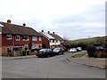
This page details the photographs taken nearby to Reeves Terrace, TN5 7RT by members of the Geograph project.
The Geograph project started in 2005 with the aim of publishing, organising and preserving representative images for every square kilometre of Great Britain, Ireland and the Isle of Man.

There are currently over 7.5m images from over14,400 individuals and you can help contribute to the project by visiting https://www.geograph.org.uk
Image Map (Loading...)


Getting Data...Please wait
Leaflet Map data © OpenStreetMap
Images are licensed for reuse under creativecommons.org/licenses/by-sa/2.0
Notes
- Clicking on the map will re-center to the selected point.
- The higher the marker number, the further away the image location is from the centre of the postcode.
Image Listing (85 Images Found)
Images are licensed for reuse under creativecommons.org/licenses/by-sa/2.0
Image
Details
Distance
8
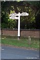
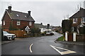
Direction Sign - Signpost by the B2099, Ticehurst
Black iron cap finial - 3 arms; East Sussex wood with number by the B2099, in parish of Ticehurst (Rother District), High Street, junction with B2087 Lower Platts, opposite tollhouse, on verge.
Surveyed
Milestone Society National ID: SX_TQ6930
Image: © Milestone Society
Taken: Unknown
0.04 miles
9
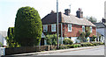
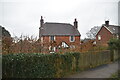
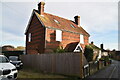
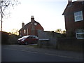
Old Toll House by the B2099, High Street, Ticehurst
Toll House in the parish of Ticehurst (Rother District), the cottage stands at the junction of High Street (B2099) and Lower Platts.
Grade II listed.
List Entry Number: 1274533 https://historicengland.org.uk/listing/the-list/list-entry/1274533
Surveyed
Milestone Society National ID: ES.TIC02
Image: © Alan Rosevear
Taken: 11 May 2008
0.04 miles