IMAGES TAKEN NEAR TO
Union Street, WADHURST, TN5 7NY
Introduction
This page details the photographs taken nearby to Union Street, TN5 7NY by members of the Geograph project.
The Geograph project started in 2005 with the aim of publishing, organising and preserving representative images for every square kilometre of Great Britain, Ireland and the Isle of Man.

There are currently over 7.5m images from over14,400 individuals and you can help contribute to the project by visiting https://www.geograph.org.uk
Image Map (Loading...)


Getting Data...Please wait
Leaflet Map data © OpenStreetMap
Images are licensed for reuse under creativecommons.org/licenses/by-sa/2.0
Notes
- Clicking on the map will re-center to the selected point.
- The higher the marker number, the further away the image location is from the centre of the postcode.
Image Listing (45 Images Found)
Images are licensed for reuse under creativecommons.org/licenses/by-sa/2.0
Image
Details
Distance
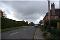
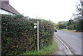
2
Sussex Border Path on Union Street
The long distance path heads left towards Ketley Wood and onwards to Rosemary Lane near Bewl Water reservoir. The path also heads right towards Quedley Farm and onwards towards Birchen Wood.
Image: © David Anstiss
Taken: 18 Apr 2010
0.04 miles
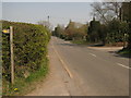
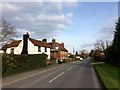
4
Sussex Border Path off the B2087, Union Street
Image: © N Chadwick
Taken: 28 Oct 2010
0.05 miles
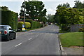
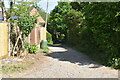
5

Sussex Border Path south of Union Street
Image: © N Chadwick
Taken: 28 Oct 2010
0.05 miles
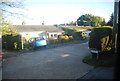
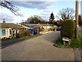
9
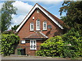
Providence Chapel
Converted chapel on the B2087 Flimwell High Street.
Image: © David Anstiss
Taken: 15 May 2011
0.07 miles