IMAGES TAKEN NEAR TO
Union Street, WADHURST, TN5 7NR
Introduction
This page details the photographs taken nearby to Union Street, TN5 7NR by members of the Geograph project.
The Geograph project started in 2005 with the aim of publishing, organising and preserving representative images for every square kilometre of Great Britain, Ireland and the Isle of Man.

There are currently over 7.5m images from over14,400 individuals and you can help contribute to the project by visiting https://www.geograph.org.uk
Image Map
Images are licensed for reuse under creativecommons.org/licenses/by-sa/2.0
Notes
- Clicking on the map will re-center to the selected point.
- The higher the marker number, the further away the image location is from the centre of the postcode.
Image Listing (51 Images Found)
Images are licensed for reuse under creativecommons.org/licenses/by-sa/2.0
Image
Details
Distance
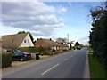
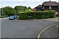
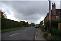
2
B2087 west of Flimwell
The name Union Street appears on the maps but it doesn't appear to refer to the B2087 at this point, so it must be the name of the hamlet?
Image: © Stuart Logan
Taken: 25 Aug 2011
0.03 miles