IMAGES TAKEN NEAR TO
Holbeam Wood, WADHURST, TN5 7JS
Introduction
This page details the photographs taken nearby to Holbeam Wood, TN5 7JS by members of the Geograph project.
The Geograph project started in 2005 with the aim of publishing, organising and preserving representative images for every square kilometre of Great Britain, Ireland and the Isle of Man.

There are currently over 7.5m images from over14,400 individuals and you can help contribute to the project by visiting https://www.geograph.org.uk
Image Map
Images are licensed for reuse under creativecommons.org/licenses/by-sa/2.0
Notes
- Clicking on the map will re-center to the selected point.
- The higher the marker number, the further away the image location is from the centre of the postcode.
Image Listing (9 Images Found)
Images are licensed for reuse under creativecommons.org/licenses/by-sa/2.0
Image
Details
Distance
1
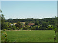
Holbeam Wood
Not a wood but a house and farm now apparently spelt Holbeam, although old maps have Holbean.
Image: © Robin Webster
Taken: 18 Aug 2012
0.01 miles
2
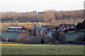
Holbeam Wood Oast, High Street, Wallcrouch, Ticehurst
Image: © Oast House Archive
Taken: 3 Jan 2009
0.01 miles
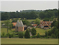
4
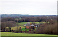
Holbeam Wood Farm
Holbean Wood Oast and Holbeam Wood Farmhouse
Two square kiln oast house and large farm house. Both are Grade II listed.
Seen from Ward's Lane.
Image: © David Anstiss
Taken: 21 Sep 2013
0.03 miles
6
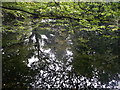
Pond beside Ward's Lane
Small pond within the woodland beside Ward's Lane.
Image: © David Anstiss
Taken: 21 Sep 2013
0.22 miles
7
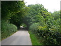
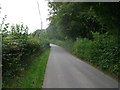
Ward's Lane
Narrow road leading from the B2099 High Street to Birchett's Green.
Passing Beechfield Wood (on the left).
Image: © David Anstiss
Taken: 21 Sep 2013
0.23 miles
8
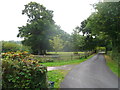
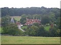
Farm road to Holbeam Wood
As seen from Ward's Lane.
A long access road leads through Holbeam Wood to the farm.
Image: © David Anstiss
Taken: 21 Sep 2013
0.24 miles
9
Ward's Lane
Narrow road leading to the B2099 High Street.
Passing Beechfield Wood.
Image: © David Anstiss
Taken: 21 Sep 2013
0.24 miles