IMAGES TAKEN NEAR TO
Singehurst Farm Close, TN5 7HG
Introduction
This page details the photographs taken nearby to Singehurst Farm Close, TN5 7HG by members of the Geograph project.
The Geograph project started in 2005 with the aim of publishing, organising and preserving representative images for every square kilometre of Great Britain, Ireland and the Isle of Man.

There are currently over 7.5m images from over14,400 individuals and you can help contribute to the project by visiting https://www.geograph.org.uk
Image Map
Images are licensed for reuse under creativecommons.org/licenses/by-sa/2.0
Notes
- Clicking on the map will re-center to the selected point.
- The higher the marker number, the further away the image location is from the centre of the postcode.
Image Listing (62 Images Found)
Images are licensed for reuse under creativecommons.org/licenses/by-sa/2.0
Image
Details
Distance
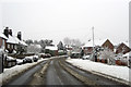
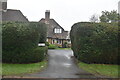
3
Upper Platts, Ticehurst, East Sussex
Image: © Oast House Archive
Taken: 3 Jan 2009
0.04 miles
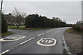
9
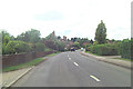
B2087 is Lower Platts
As the B2087 enters Ticehurst it acquires the name.
Image: © Stuart Logan
Taken: 25 Aug 2011
0.12 miles