IMAGES TAKEN NEAR TO
Hurst Wood Close, WADHURST, TN5 7FD
Introduction
This page details the photographs taken nearby to Hurst Wood Close, TN5 7FD by members of the Geograph project.
The Geograph project started in 2005 with the aim of publishing, organising and preserving representative images for every square kilometre of Great Britain, Ireland and the Isle of Man.

There are currently over 7.5m images from over14,400 individuals and you can help contribute to the project by visiting https://www.geograph.org.uk
Image Map (Loading...)


Getting Data...Please wait
Leaflet Map data © OpenStreetMap
Images are licensed for reuse under creativecommons.org/licenses/by-sa/2.0
Notes
- Clicking on the map will re-center to the selected point.
- The higher the marker number, the further away the image location is from the centre of the postcode.
Image Listing (50 Images Found)
Images are licensed for reuse under creativecommons.org/licenses/by-sa/2.0
Image
Details
Distance
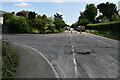

9
B2087 west of Flimwell
The name Union Street appears on the maps but it doesn't appear to refer to the B2087 at this point, so it must be the name of the hamlet?
Image: © Stuart Logan
Taken: 25 Aug 2011
0.10 miles
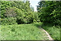
10
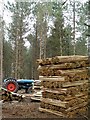
Chestnut Coppicing
Chestnut coppicing being carried out in woodland close to Bewl Water. Fencing stakes bundled and ready for collection.
Image: © Tim Knight
Taken: 22 Mar 2006
0.11 miles