IMAGES TAKEN NEAR TO
Owls Gardens, Cottenden Road, WADHURST, TN5 7DZ
Introduction
This page details the photographs taken nearby to Owls Gardens, Cottenden Road, TN5 7DZ by members of the Geograph project.
The Geograph project started in 2005 with the aim of publishing, organising and preserving representative images for every square kilometre of Great Britain, Ireland and the Isle of Man.

There are currently over 7.5m images from over14,400 individuals and you can help contribute to the project by visiting https://www.geograph.org.uk
Image Map (Loading...)


Getting Data...Please wait
Leaflet Map data © OpenStreetMap
Images are licensed for reuse under creativecommons.org/licenses/by-sa/2.0
Notes
- Clicking on the map will re-center to the selected point.
- The higher the marker number, the further away the image location is from the centre of the postcode.
Image Listing (106 Images Found)
Images are licensed for reuse under creativecommons.org/licenses/by-sa/2.0
Image
Details
Distance
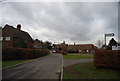
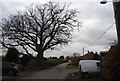
1
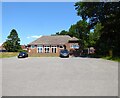
Owls Gardens, Stonegate
A set of six cottages built in the 1940s.
Image: © Simon Carey
Taken: 7 Jul 2023
0.00 miles
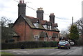
4
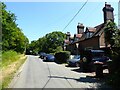
Owls Castle Cottages, Cottenden Road, Stonegate
The cottages date back to the 19th century.
Image: © Simon Carey
Taken: 7 Jul 2023
0.02 miles
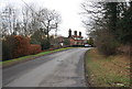
6
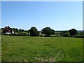
Nats Croft
The name of the field according to Ticehurst's 1839 tithe map located to the south of Cottenden Road with Owls Gardens to the left.
Image: © Simon Carey
Taken: 7 Jul 2023
0.05 miles
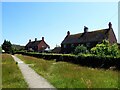
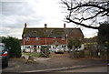
8
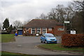
Village Hall, Forge Field, Stonegate
The local community centre was built in 1959
Image: © Simon Carey
Taken: 7 Jul 2023
0.05 miles