IMAGES TAKEN NEAR TO
Wardsbrook Road, WADHURST, TN5 7DP
Introduction
This page details the photographs taken nearby to Wardsbrook Road, TN5 7DP by members of the Geograph project.
The Geograph project started in 2005 with the aim of publishing, organising and preserving representative images for every square kilometre of Great Britain, Ireland and the Isle of Man.

There are currently over 7.5m images from over14,400 individuals and you can help contribute to the project by visiting https://www.geograph.org.uk
Image Map (Loading...)


Getting Data...Please wait
Leaflet Map data © OpenStreetMap
Images are licensed for reuse under creativecommons.org/licenses/by-sa/2.0
Notes
- Clicking on the map will re-center to the selected point.
- The higher the marker number, the further away the image location is from the centre of the postcode.
Image Listing (50 Images Found)
Images are licensed for reuse under creativecommons.org/licenses/by-sa/2.0
Image
Details
Distance
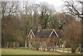
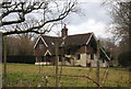
1
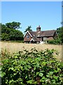
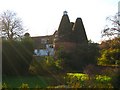
Keeper's Oak Cottage
Not marked on Ticehurst's 1839 tithe map but does appear on the 1872 OS map.
Image: © Simon Carey
Taken: 7 Jul 2023
0.00 miles
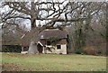
5
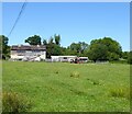
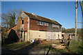
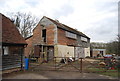
Barn, Wedd's Farm
Located on the eastern side.
Image: © Simon Carey
Taken: 7 Jul 2023
0.04 miles
6
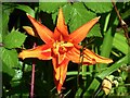
Tiger Lily (Lilium bulbiferum)
Located in the hedgerow that forms the southern boundary of Keeper's Oak Cottage.
Image: © Simon Carey
Taken: 7 Jul 2023
0.05 miles