IMAGES TAKEN NEAR TO
St. Marys Lane, WADHURST, TN5 7AX
Introduction
This page details the photographs taken nearby to St. Marys Lane, TN5 7AX by members of the Geograph project.
The Geograph project started in 2005 with the aim of publishing, organising and preserving representative images for every square kilometre of Great Britain, Ireland and the Isle of Man.

There are currently over 7.5m images from over14,400 individuals and you can help contribute to the project by visiting https://www.geograph.org.uk
Image Map (Loading...)


Getting Data...Please wait
Leaflet Map data © OpenStreetMap
Images are licensed for reuse under creativecommons.org/licenses/by-sa/2.0
Notes
- Clicking on the map will re-center to the selected point.
- The higher the marker number, the further away the image location is from the centre of the postcode.
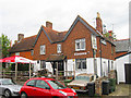
Image Listing (233 Images Found)
Images are licensed for reuse under creativecommons.org/licenses/by-sa/2.0
Image
Details
Distance
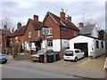
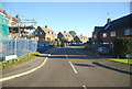
7
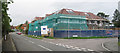
New Development at Springfields
New 2 1/2 storey building nearing completion at junction of Springfields onto High Street. The building replacing a pair of semi detached houses.
Image: © Oast House Archive
Taken: 3 Oct 2010
0.03 miles
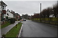
8
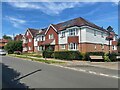
Flats at Woodroffe and Springfields junction
Image: © Oast House Archive
Taken: 23 Jul 2021
0.04 miles