IMAGES TAKEN NEAR TO
Riverhall Hill, WADHURST, TN5 6LF
Introduction
This page details the photographs taken nearby to Riverhall Hill, TN5 6LF by members of the Geograph project.
The Geograph project started in 2005 with the aim of publishing, organising and preserving representative images for every square kilometre of Great Britain, Ireland and the Isle of Man.

There are currently over 7.5m images from over14,400 individuals and you can help contribute to the project by visiting https://www.geograph.org.uk
Image Map
Images are licensed for reuse under creativecommons.org/licenses/by-sa/2.0
Notes
- Clicking on the map will re-center to the selected point.
- The higher the marker number, the further away the image location is from the centre of the postcode.
Image Listing (73 Images Found)
Images are licensed for reuse under creativecommons.org/licenses/by-sa/2.0
Image
Details
Distance
1
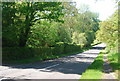
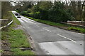
The B2009
The B2099 runs between Ticehurst and Frant, both in East Sussex.
Image: © N Chadwick
Taken: 22 May 2010
0.02 miles
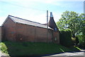
3
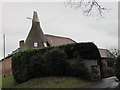
Greenmans Oast, Wadhurst Road, Wadhurst, East Sussex
Image: © Oast House Archive
Taken: 1 Nov 2010
0.04 miles
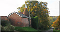
4
Greenmans Oast, Wadhurst Road, Wadhurst, East Sussex
Single round kiln oast house.
Image: © Oast House Archive
Taken: 21 Mar 2009
0.04 miles
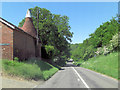
7
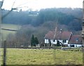
Sussex Weatherboarded Cottage by the B2099
These weatherboarded cottages are common around here. The scenery behind the cottage is also very typical of the Sussex Weald.
Image: © N Chadwick
Taken: 19 Feb 2009
0.05 miles
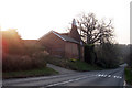
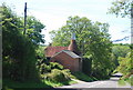
10
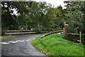
Durgates, Riverhall Hill: Bridge over a stream
Image: © Michael Garlick
Taken: 23 Sep 2020
0.07 miles