IMAGES TAKEN NEAR TO
Mayfield Lane, WADHURST, TN5 6HX
Introduction
This page details the photographs taken nearby to Mayfield Lane, TN5 6HX by members of the Geograph project.
The Geograph project started in 2005 with the aim of publishing, organising and preserving representative images for every square kilometre of Great Britain, Ireland and the Isle of Man.

There are currently over 7.5m images from over14,400 individuals and you can help contribute to the project by visiting https://www.geograph.org.uk
Image Map (Loading...)


Getting Data...Please wait
Leaflet Map data © OpenStreetMap
Images are licensed for reuse under creativecommons.org/licenses/by-sa/2.0
Notes
- Clicking on the map will re-center to the selected point.
- The higher the marker number, the further away the image location is from the centre of the postcode.
Image Listing (8 Images Found)
Images are licensed for reuse under creativecommons.org/licenses/by-sa/2.0
Image
Details
Distance
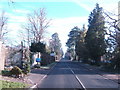
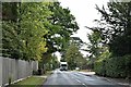
1
Mayfield Lane
This road (the B2100) leads from Wadhurst towards Best Beech Hill.
Image: © David Anstiss
Taken: 31 Aug 2013
0.05 miles
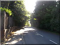
2
Windmill Lane
Leads from Mayfield Lane towards Windmill Lodge and Windmill Farm.
Image: © David Anstiss
Taken: 31 Aug 2013
0.06 miles
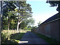
3
Mayfield Lane (B2100)
Heading towards Best Beech Hill. The railway line runs in a tunnel underneath just ahead.
Image: © Julian P Guffogg
Taken: 5 Oct 2013
0.07 miles
4
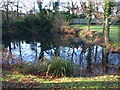
The pond in front of the Priest's Cottage, Mayfield Lane
Image: © Michael Flegg
Taken: 2 Dec 2008
0.10 miles

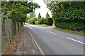
7
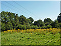
Rough field off Tapsell's Lane
The power lines are connected to a substation hidden in the trees.
Image: © Robin Webster
Taken: 18 Aug 2012
0.21 miles