IMAGES TAKEN NEAR TO
Newbury Lane, WADHURST, TN5 6HB
Introduction
This page details the photographs taken nearby to Newbury Lane, TN5 6HB by members of the Geograph project.
The Geograph project started in 2005 with the aim of publishing, organising and preserving representative images for every square kilometre of Great Britain, Ireland and the Isle of Man.

There are currently over 7.5m images from over14,400 individuals and you can help contribute to the project by visiting https://www.geograph.org.uk
Image Map
Images are licensed for reuse under creativecommons.org/licenses/by-sa/2.0
Notes
- Clicking on the map will re-center to the selected point.
- The higher the marker number, the further away the image location is from the centre of the postcode.
Image Listing (13 Images Found)
Images are licensed for reuse under creativecommons.org/licenses/by-sa/2.0
Image
Details
Distance
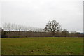
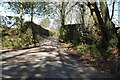
2

Monks Lane
This is just north of the hamlet of Cousley Wood.
Image: © Marathon
Taken: 28 Nov 2020
0.08 miles
4

Old Direction Sign - Signpost by Monks Lane, Wadhurst
Black iron cap finial - 4 arms; East Sussex wood by the UC road, in parish of Wadhurst (Wealden District), intersection of Newbury Lane with Monks Lane, on grass verge.
Surveyed
Milestone Society National ID: SX_TQ6434A
Image: © Milestone Society
Taken: Unknown
0.12 miles
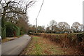
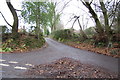
6
Sleepers Stile Rd, Free Heath Rd junction
Image: © N Chadwick
Taken: 9 Mar 2021
0.20 miles
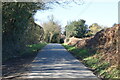
8
Lane to Free Heath, off Sleepers Stile road
Image: © Julian P Guffogg
Taken: 27 Dec 2011
0.21 miles
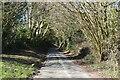
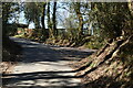
10

Footpath to Monks Lane
This is the footpath leading from Cousley Wood to Monks Lane.
Image: © Marathon
Taken: 28 Nov 2020
0.23 miles