IMAGES TAKEN NEAR TO
Lower High Street, WADHURST, TN5 6AY
Introduction
This page details the photographs taken nearby to Lower High Street, TN5 6AY by members of the Geograph project.
The Geograph project started in 2005 with the aim of publishing, organising and preserving representative images for every square kilometre of Great Britain, Ireland and the Isle of Man.

There are currently over 7.5m images from over14,400 individuals and you can help contribute to the project by visiting https://www.geograph.org.uk
Image Map
Images are licensed for reuse under creativecommons.org/licenses/by-sa/2.0
Notes
- Clicking on the map will re-center to the selected point.
- The higher the marker number, the further away the image location is from the centre of the postcode.
Image Listing (151 Images Found)
Images are licensed for reuse under creativecommons.org/licenses/by-sa/2.0
Image
Details
Distance
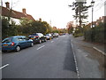
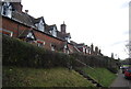
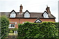
1
Mount Pleasant
Grade II listed. https://historicengland.org.uk/listing/the-list/list-entry/1028075
Image: © N Chadwick
Taken: 22 May 2020
0.01 miles
2
Mount Pleasant
Grade II listed. http://www.britishlistedbuildings.co.uk/en-296797-mount-pleasant-1-4-wadhurst
Image: © N Chadwick
Taken: 15 Feb 2012
0.02 miles
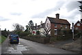
3
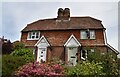
Kemps Cottage
Grade II listed. https://historicengland.org.uk/listing/the-list/list-entry/1194696
Image: © N Chadwick
Taken: 22 May 2020
0.02 miles
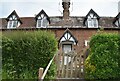
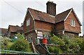
4
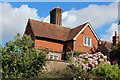
Youth Centre, Lower High Street
Grade II listed https://historicengland.org.uk/listing/the-list/list-entry/1028074
Image: © Oast House Archive
Taken: 16 Aug 2014
0.03 miles
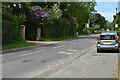
5
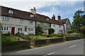
Laurel Bank Terrace
Grade II listed. https://historicengland.org.uk/listing/the-list/list-entry/1353746
Image: © N Chadwick
Taken: 22 May 2020
0.03 miles
7
Wadhurst Youth Centre
Grade II listed. https://historicengland.org.uk/listing/the-list/list-entry/1028074
Image: © N Chadwick
Taken: 22 May 2020
0.04 miles