IMAGES TAKEN NEAR TO
St. Johns Road, TUNBRIDGE WELLS, TN4 9XD
Introduction
This page details the photographs taken nearby to St. Johns Road, TN4 9XD by members of the Geograph project.
The Geograph project started in 2005 with the aim of publishing, organising and preserving representative images for every square kilometre of Great Britain, Ireland and the Isle of Man.

There are currently over 7.5m images from over14,400 individuals and you can help contribute to the project by visiting https://www.geograph.org.uk
Image Map (Loading...)


Getting Data...Please wait
Leaflet Map data © OpenStreetMap
Images are licensed for reuse under creativecommons.org/licenses/by-sa/2.0
Notes
- Clicking on the map will re-center to the selected point.
- The higher the marker number, the further away the image location is from the centre of the postcode.
Image Listing (297 Images Found)
Images are licensed for reuse under creativecommons.org/licenses/by-sa/2.0
Image
Details
Distance
2
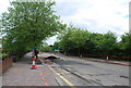
Resurfacing St John's Road
On June 21st 2009, the A26 was closed completely in Tunbridge Wells for resurfacing.
Image: © N Chadwick
Taken: 21 Jun 2009
0.02 miles

10
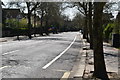
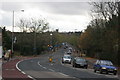
Empty A26
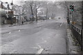
A normally busy road devoid of traffic on day 18 of the COVID-19 lockdown.
Image: © N Chadwick
Taken: 10 Apr 2020
0.06 miles