IMAGES TAKEN NEAR TO
Kendal Park, TUNBRIDGE WELLS, TN4 9SX
Introduction
This page details the photographs taken nearby to Kendal Park, TN4 9SX by members of the Geograph project.
The Geograph project started in 2005 with the aim of publishing, organising and preserving representative images for every square kilometre of Great Britain, Ireland and the Isle of Man.

There are currently over 7.5m images from over14,400 individuals and you can help contribute to the project by visiting https://www.geograph.org.uk
Image Map
Images are licensed for reuse under creativecommons.org/licenses/by-sa/2.0
Notes
- Clicking on the map will re-center to the selected point.
- The higher the marker number, the further away the image location is from the centre of the postcode.
Image Listing (190 Images Found)
Images are licensed for reuse under creativecommons.org/licenses/by-sa/2.0
Image
Details
Distance
1
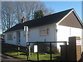
Rose Hill School Shop
At the end of Rydal Close.
See http://rosehillschool.info/uniform/index.php?mode=catalog for more info on the Uniform Shop.
Image: © David Anstiss
Taken: 1 Mar 2010
0.03 miles
2
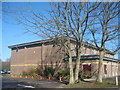
Rose Hill School Sports Block
As seen from Rydal Close.
Image: © David Anstiss
Taken: 1 Mar 2010
0.05 miles

4
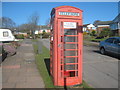
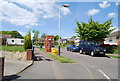
Red Telephone Box
On Rydal Drive. No longer taking coins, only phonecards and credit cards.
Image: © David Anstiss
Taken: 1 Mar 2010
0.05 miles