IMAGES TAKEN NEAR TO
Culverden Down, TUNBRIDGE WELLS, TN4 9RX
Introduction
This page details the photographs taken nearby to Culverden Down, TN4 9RX by members of the Geograph project.
The Geograph project started in 2005 with the aim of publishing, organising and preserving representative images for every square kilometre of Great Britain, Ireland and the Isle of Man.

There are currently over 7.5m images from over14,400 individuals and you can help contribute to the project by visiting https://www.geograph.org.uk
Image Map (Loading...)


Getting Data...Please wait
Leaflet Map data © OpenStreetMap
Images are licensed for reuse under creativecommons.org/licenses/by-sa/2.0
Notes
- Clicking on the map will re-center to the selected point.
- The higher the marker number, the further away the image location is from the centre of the postcode.
Image Listing (121 Images Found)
Images are licensed for reuse under creativecommons.org/licenses/by-sa/2.0
Image
Details
Distance
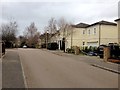
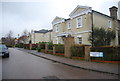
1
Huntleys Park
This housing development is built on the site of the old Huntley Park School
Image: © N Chadwick
Taken: 5 Dec 2009
0.10 miles

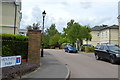
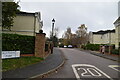
4
Huntleys Park
This development of Georgian style homes was built on the site of the former Huntleys school.
Image: © N Chadwick
Taken: 16 Nov 2008
0.11 miles
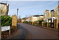
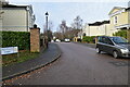
6

Huntleys Park
A housing estate build on the grounds of Huntleys School.
Image: © N Chadwick
Taken: 13 Apr 2020
0.11 miles
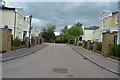
8
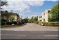
Huntleys Park, Culverden Down
These houses were built on the site of the old Huntleys Boy's School
Image: © N Chadwick
Taken: 2 May 2009
0.11 miles