IMAGES TAKEN NEAR TO
Richardson Road, TUNBRIDGE WELLS, TN4 9PB
Introduction
This page details the photographs taken nearby to Richardson Road, TN4 9PB by members of the Geograph project.
The Geograph project started in 2005 with the aim of publishing, organising and preserving representative images for every square kilometre of Great Britain, Ireland and the Isle of Man.

There are currently over 7.5m images from over14,400 individuals and you can help contribute to the project by visiting https://www.geograph.org.uk
Image Map (Loading...)


Getting Data...Please wait
Leaflet Map data © OpenStreetMap
Images are licensed for reuse under creativecommons.org/licenses/by-sa/2.0
Notes
- Clicking on the map will re-center to the selected point.
- The higher the marker number, the further away the image location is from the centre of the postcode.
Image Listing (1643 Images Found)
Images are licensed for reuse under creativecommons.org/licenses/by-sa/2.0
Image
Details
Distance
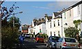
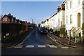
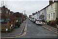
4
Newcomen Rd
An street of early Edwardian houses and villas.
Image: © N Chadwick
Taken: 20 Mar 2010
0.02 miles
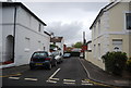
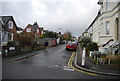
5
The corner of Stephen's Rd & Currie Rd
In the back of the photo is the back of The Skinners' School.
Image: © N Chadwick
Taken: 17 Jan 2009
0.03 miles
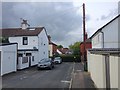
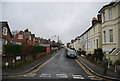
8
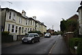
Stephen's Rd
An street of early Edwardian houses and villas.
Image: © N Chadwick
Taken: 20 Mar 2010
0.03 miles