IMAGES TAKEN NEAR TO
All Saints Road, TUNBRIDGE WELLS, TN4 9JF
Introduction
This page details the photographs taken nearby to All Saints Road, TN4 9JF by members of the Geograph project.
The Geograph project started in 2005 with the aim of publishing, organising and preserving representative images for every square kilometre of Great Britain, Ireland and the Isle of Man.

There are currently over 7.5m images from over14,400 individuals and you can help contribute to the project by visiting https://www.geograph.org.uk
Image Map
Images are licensed for reuse under creativecommons.org/licenses/by-sa/2.0
Notes
- Clicking on the map will re-center to the selected point.
- The higher the marker number, the further away the image location is from the centre of the postcode.
Image Listing (1223 Images Found)
Images are licensed for reuse under creativecommons.org/licenses/by-sa/2.0
Image
Details
Distance
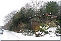
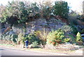
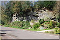
1
Tunbridge Wells Sandstone Cliff, All Saints Rd
One of several outcrops of this sandstone in the Tunbridge Wells area. The sandstone is Lower Cretaceous in age, formed by rivers.
Image: © N Chadwick
Taken: 20 Jun 2010
0.01 miles
2
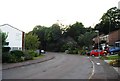
Bend in All Saints Rd
A 1970s estate rd.
Image: © N Chadwick
Taken: 27 Sep 2009
0.01 miles
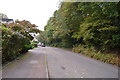
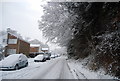
5
Sandstone cliff on All Saints Rd
Tunbridge Wells Sandstone (Cretaceous in age)
Image: © N Chadwick
Taken: 22 Nov 2008
0.02 miles
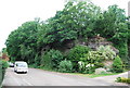
6
Sandstone cliff
Tunbridge Wells Sandstone (Cretaceous)
Image: © N Chadwick
Taken: 15 Apr 2008
0.03 miles
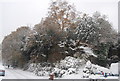
7
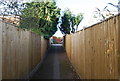
Cut through from All Saints Rd to St Michaels Rd
Image: © N Chadwick
Taken: 22 Nov 2008
0.03 miles