IMAGES TAKEN NEAR TO
Lower Green Road, TUNBRIDGE WELLS, TN4 8TE
Introduction
This page details the photographs taken nearby to Lower Green Road, TN4 8TE by members of the Geograph project.
The Geograph project started in 2005 with the aim of publishing, organising and preserving representative images for every square kilometre of Great Britain, Ireland and the Isle of Man.

There are currently over 7.5m images from over14,400 individuals and you can help contribute to the project by visiting https://www.geograph.org.uk
Image Map (Loading...)


Getting Data...Please wait
Leaflet Map data © OpenStreetMap
Images are licensed for reuse under creativecommons.org/licenses/by-sa/2.0
Notes
- Clicking on the map will re-center to the selected point.
- The higher the marker number, the further away the image location is from the centre of the postcode.
Image Listing (230 Images Found)
Images are licensed for reuse under creativecommons.org/licenses/by-sa/2.0
Image
Details
Distance
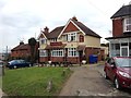
4
White Hart, Rusthall
Public house in the centre of the village.
Image: © N Chadwick
Taken: 16 Nov 2008
0.01 miles
5
The White Hart Pub, Rusthall
On Lower Green Road.
Image: © David Anstiss
Taken: 1 Mar 2010
0.01 miles
7
The White Hart (closed)
Day 56 of the COVID-19 lockdown and all pubs, bars and restaurants remain closed.
Image: © N Chadwick
Taken: 18 May 2020
0.01 miles