IMAGES TAKEN NEAR TO
Sunnyside Road, TUNBRIDGE WELLS, TN4 8RB
Introduction
This page details the photographs taken nearby to Sunnyside Road, TN4 8RB by members of the Geograph project.
The Geograph project started in 2005 with the aim of publishing, organising and preserving representative images for every square kilometre of Great Britain, Ireland and the Isle of Man.

There are currently over 7.5m images from over14,400 individuals and you can help contribute to the project by visiting https://www.geograph.org.uk
Image Map (Loading...)


Getting Data...Please wait
Leaflet Map data © OpenStreetMap
Images are licensed for reuse under creativecommons.org/licenses/by-sa/2.0
Notes
- Clicking on the map will re-center to the selected point.
- The higher the marker number, the further away the image location is from the centre of the postcode.
Image Listing (271 Images Found)
Images are licensed for reuse under creativecommons.org/licenses/by-sa/2.0
Image
Details
Distance
3
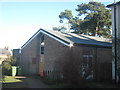
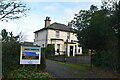
Sunnyside Community Hall
Beside Sunnyside House on Rusthall Road.
Hall also used by Rusthall Scouts and Holding Hands - preschool nursery
Image: © David Anstiss
Taken: 1 Mar 2010
0.06 miles