IMAGES TAKEN NEAR TO
Grange Road, TUNBRIDGE WELLS, TN4 8PU
Introduction
This page details the photographs taken nearby to Grange Road, TN4 8PU by members of the Geograph project.
The Geograph project started in 2005 with the aim of publishing, organising and preserving representative images for every square kilometre of Great Britain, Ireland and the Isle of Man.

There are currently over 7.5m images from over14,400 individuals and you can help contribute to the project by visiting https://www.geograph.org.uk
Image Map (Loading...)


Getting Data...Please wait
Leaflet Map data © OpenStreetMap
Images are licensed for reuse under creativecommons.org/licenses/by-sa/2.0
Notes
- Clicking on the map will re-center to the selected point.
- The higher the marker number, the further away the image location is from the centre of the postcode.
Image Listing (384 Images Found)
Images are licensed for reuse under creativecommons.org/licenses/by-sa/2.0
Image
Details
Distance
3
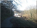
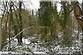
Footpath through Still Green
This path leads from Coniston Avenue towards Woodside Road (in the background).
Image: © David Anstiss
Taken: 1 Mar 2010
0.04 miles
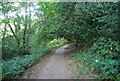
7
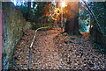
Street light on a footpath, Rusthall
With darkness starting to fall, the light on & a carpet of leaves, the area takes on a magical property.
Image: © N Chadwick
Taken: 16 Nov 2008
0.05 miles