IMAGES TAKEN NEAR TO
High Rocks Lane, TUNBRIDGE WELLS, TN4 8FR
Introduction
This page details the photographs taken nearby to High Rocks Lane, TN4 8FR by members of the Geograph project.
The Geograph project started in 2005 with the aim of publishing, organising and preserving representative images for every square kilometre of Great Britain, Ireland and the Isle of Man.

There are currently over 7.5m images from over14,400 individuals and you can help contribute to the project by visiting https://www.geograph.org.uk
Image Map
Images are licensed for reuse under creativecommons.org/licenses/by-sa/2.0
Notes
- Clicking on the map will re-center to the selected point.
- The higher the marker number, the further away the image location is from the centre of the postcode.
Image Listing (138 Images Found)
Images are licensed for reuse under creativecommons.org/licenses/by-sa/2.0
Image
Details
Distance

5
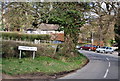
Entering Tunbridge Wells on the High Rocks Road
Image: © N Chadwick
Taken: 15 Apr 2008
0.03 miles
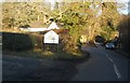
7

Entering Tunbridge Wells, High Rocks Lane
Image: © N Chadwick
Taken: 9 Feb 2021
0.04 miles
8
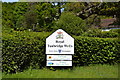
Entering Royal Tunbridge Wells, High Rocks Lane
Image: © N Chadwick
Taken: 30 Jan 2011
0.04 miles
9
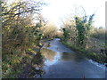
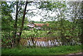
High Rocks Lane
This view looks back in the direction of Tunbridge Wells Common. Although this day was dry, mild and sunny it had rained the whole of the previous day - hence the surface water on the road.
Image: © Marathon
Taken: 22 Dec 2013
0.04 miles