IMAGES TAKEN NEAR TO
Pennington Road, TUNBRIDGE WELLS, TN4 0SQ
Introduction
This page details the photographs taken nearby to Pennington Road, TN4 0SQ by members of the Geograph project.
The Geograph project started in 2005 with the aim of publishing, organising and preserving representative images for every square kilometre of Great Britain, Ireland and the Isle of Man.

There are currently over 7.5m images from over14,400 individuals and you can help contribute to the project by visiting https://www.geograph.org.uk
Image Map
Images are licensed for reuse under creativecommons.org/licenses/by-sa/2.0
Notes
- Clicking on the map will re-center to the selected point.
- The higher the marker number, the further away the image location is from the centre of the postcode.
Image Listing (483 Images Found)
Images are licensed for reuse under creativecommons.org/licenses/by-sa/2.0
Image
Details
Distance
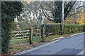
3
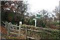
Tunbridge Wells Circular Path off Pennington Rd
Image: © N Chadwick
Taken: 17 Nov 2012
0.03 miles
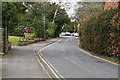
5
Tunbridge Wells Circular Walk off Pennington Rd
Image: © N Chadwick
Taken: 12 Nov 2020
0.03 miles
6
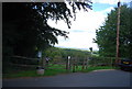
Tunbridge Wells Circular Path of Pennington Rd
Image: © N Chadwick
Taken: 12 Sep 2010
0.04 miles
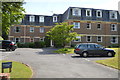
7
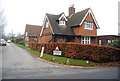
Large house at the end of Vicarage Rd, Southborough
Vicarage Rd is a private road. Cars are wheel clamped!
Image: © N Chadwick
Taken: 29 Nov 2008
0.04 miles
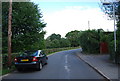
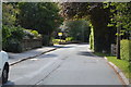
10
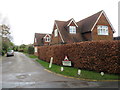
Vicarage Road, Southborough
Vicarage Road in Southborough, near Tunbridge Wells in Kent.
This road is on the route of the Tunbridge Wells Circular Walk, a series of circular walks in and around Tunbridge Wells.
Image: © Malc McDonald
Taken: 29 Feb 2020
0.04 miles